Article No. 9-AKSAI CHIN – 4 : STATE OF AKSAI CHIN AS ON 01 JAN 1913
Why 01 Jan 1913? We must know where Aksai Chin stood on 01 Jan 1913. British-India and Qing Dynasty bid farewell in 1912. This part summarizes the developments up to 1912.
From 1913 the PGRC took over reins of China. Once PGRC took over the complete country and the administered lands, it had little experience in handling issues and would fall back on the lines, accords, treaties and agreements none of which were bilateral. This is the most important aspect. With no bilateral understanding each side was open to its own interpretation of the border between British-India and Tibet or British-India and East Turkistan. Both these areas were under direct control of PGRC. There was no historical record of a bilateral agreement and China always maintained that neither Tibet nor East Turkistan had any right to sign any treaties with foreign countries.
The previous five hundred years have been covered in the previous eight articles. The most crucial period was from 1840 to 1912, from Sikh-Dogra war against Tibetans (Qing Dynasty Army) in 1840 to 1912 when Qing Dynasty was removed and Provisional Government of Republic of China (PGRC) inherited complete holdings of Qing Dynasty.
So what was the state on 01 Jan 1913? Have a look at the physical map of the area at MAP-1 below. The maps used so far have been generic in details to bring the reader to understand the history, geography and the politics from 1840 to 1912. Its important to introduce physical maps at this stage in order to co-relate names commonly heard with the ground. See MAP-1 below, it gives out two distinct areas of ‘China Occupied Kashmir’ containing Aksai Chin and Shaksgam Valley.

Map-1
Look at the area marked ‘Aksai Chin’. The same area on physical map looks like depicted on MAP-2 below. The blue line approximately denotes the international boundary of India as shown in government maps. Area WEST of the blue line is Indian territory and is shown on the Government website. Aksai Chin and Shaksgam Valley are very much part of India as per Government maps.

Map-2
It will be very easy to comprehend the genesis of the India-China border issue looking at MAP-2. We now just need to recall the different lines drawn by the British between 1865 and 1899. To recall, the MAP-3 below

Map-3
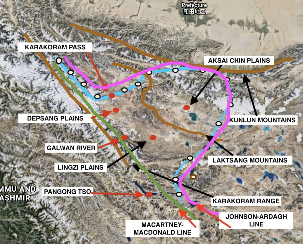
I will not transpose the two lines, Johnson-Ardagh Line 1865 & 1897 and the Macartney-Macdonald Line 1899 on the physical Map-2. See how it looks now in Map-4 below:

Map-4
With the two lines inserted on the physical map, in pink the Johnson-Ardagh Line of 1865 and 1897 and in green the Macartney-Macdonald Line of 1899, it can be clearly seen that with no bilateral agreement each country will pick up what suited their interests.
PGRC took advantage of the situation and disregarded all agreements and understanding and supported the Macartney-Macdonald line that gave almost 38,000 sq km of Aksai Chin to China while India selected the Johnson-Ardagh Line and published maps. Both of these actions did not happen in 1913. In fact no action took place for four decades and the entire area and border issue was left unaddressed.
Thus for the first time in 1913 the seeds of clash were sown.
Please understand and digest the maps. In the next article I will cover period from 1913 to 1947, i.e. the year India got independence. China was still under PGRC.
Col Sanjay Pande
© Copyright
One thought on “Article No. 9-AKSAI CHIN – 4 : STATE OF AKSAI CHIN AS ON 01 JAN 1913”
Leave a Reply
Recent Posts
Mr Macha was born about two weeks ago. He is the first case where he grew each day by one year! He is 19 years old today. Mr Macha is all fun, frolic, health conscious and really cares about...
2012-Present : Advisor-Consultant for MNCs (Multi National Companies) Details covered separately on the website. 2012 - Present Kshemin Technologies Pvt. Ltd. Founded an independent...


You’re so interesting! I don’t think I have read a single thing
like that before. So nice to find someone with original thoughts on this issue.
Seriously.. thanks for starting this up. This web site
is something that is required on the internet, someone with
a little originality!