
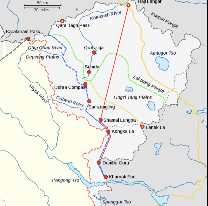
In 1823, Dogras were given Jammu and Kashmir by the SIKHS. In 1841-42, Zorawar Singh attacked Tibet, the first treaty was born. 1842 Chushul Treaty. The seeds of mess were sown.
The common factor for next 72 years was just one. Qing Dynasty. In 1912, Qing Dynasty was eased out by Provisional Government of Republic of China (PGRC). With one of the three parties involved remaining unchanged, it would be logical to know the developments from 1840 to 1912, the period of mess.
The Dogra-Tibetan War or Sino-Sikh War was fought from May 1841 to Aug 1842. Immediately after the loss in 1841, the Dogra Army retreated up to Leh on reinforcements reaching, defeated Qing’s Army. The Chushul Treaty was signed between Dogras and Qing. It would be of interest to know that Dogras ruled from Rudok (easternmost tip of Panging Tso Lake to Mayun Pass (North West corner of Nepal Border). Mansarovar was under Dogras. The line joining Mayum Pass, Gartok, Rudok was under Dogras. These areas were part of Ladakh and mentioned in a treaty of 1648 AD.
1842. The 1842 treaty between SIKHS and QINGS left everything as was before war. The agreed to ‘not to interfere at all with the boundaries of Ladakh and its surroundings as fixed from ancient times’.
1845-46. Three years later, the First Anglo-Sikh War was fought in 1845 and 1846. Sikh kingdom was partially subjugated and resulted in separation of Jammu and Kashmir as a separate princely state under British. All matters of Ladakh now came under Britain.
1865. The birth of Johnson-Ardagh Line. In 1865, William Johnson of Survey of India proposed Johnson line which put Aksai Chin in Kashmir. This line over Kunlun Mountain Range gives the ‘bulge’ shape to Aksai Chin as is depicted in Indian maps.
Aksai Chin was a game played by British with China and Russia. Britain was determined to halt Russian expansionism and would constantly manipulate the boundaries. Britain has Counsels in Beijing, St. Petersberg and Kashgar besides Governor General in India. Britain was the only common country represented in China, India and Russia.
1893. China did not object to, neither accepted Johnson Line up to 1893 but adhered to the boundary. In 1893, it submitted a map through its official in St Petersburg to George Macartney, the British council in Kashgar with slightly different border. This border coincided with Johnson line.
1896-99. Meanwhile, in 1896 China showed interest in Aksai Chin. Britain, playing their game to control Russia, now proposed Macartney–MacDonald in 1899. This line cut Aksai Chin bulge in half in the NW-SE alignment. Laktsang range is laid in this alignment. The eastern portion was shown in Chinese territory where as the western portion was shown with British India.
1897. In 1897 John Ardagh, a British military officer proposed a boundary alignment which was nearly coinciding with the 1865 Johnson line. This line became known as Johnson-Ardagh Line. Aksai Chin was completely put in India.
1840-1900 Summary. The Dogra-Qing Treaty of 1842 accepted Ladakh to be traditional Indian area. The Johnson-Ardagh Line of 1865 and 1897 and the Macartney–MacDonald line of 1899 contain between then the area between Laktsang Mountain Range and Kunlun Mountain Range. While the Johnson-Ardagh Line puts complete Aksai Chin with India, the Macartney–MacDonald Line puts eastern half of the bulge with China. These 60 years the only common party in all events was Britain. Tibet remained under Qing Dynasty.
The 1904 treaty between Britain and Tibet (covered earlier under Understanding Tibet) in Lahsa was repudiated by resident of Qing Dynasty. In 1912, Qing Dynasty came to close and the Provisional Government of Republic of China (PGRC) took over China.
In this series I have covered the following so far:
CHINA WOES : EDITORIAL 14 Feb 2021
HIMALAYAS OR 1959 CLAIM LINE? 16 Feb 2021
HIMALAYAS : INDIA AND CHINA 17 Feb 2021
TIBET AT CENTRE : INDIA-CHINA SANDWICH 18 Feb 2021
And the current article
1840-1912 – DOGRAS-CHINA-BRITAIN – 72 YEARS OF MESS 20 Feb 2021
These five articles will cover 500 years and bring the readers up to 1912. It gives sufficient information to carry out personal research.
72 years of mess is what Britain created in the region. I have covered entire geographical region from the largest towards smallest area. At the core was AKSAI CHIN. Can we go ahead if we don’t know WHAT Aksai Chin is? My next article covers it.
Col Sanjay Pande
© Copyright
Map is attributed to internet.
Recent Posts
Mr Macha was born about two weeks ago. He is the first case where he grew each day by one year! He is 19 years old today. Mr Macha is all fun, frolic, health conscious and really cares about...
2012-Present : Advisor-Consultant for MNCs (Multi National Companies) Details covered separately on the website. 2012 - Present Kshemin Technologies Pvt. Ltd. Founded an independent...