
NO, NO & NO, ‘CHIN” in Aksai Chin is NOT “CHINA”. Do not be afraid to use it, do not hesitate to use it. 60’s to 90’s Indian maps had prominent AKSAI CHIN written. Not anymore. It is not an unknown land.
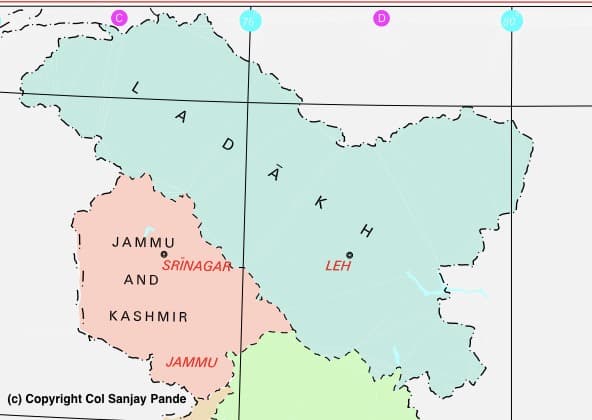
The theme of this article changed after I realized that most people had no idea of, not only Aksai Chin, but even Pakistan Occupied Kashmir. I put four questions on social media putting Map-1 below and asked the following:
- Put your finger on Aksai Chin.
- Put your finger on Shaksgam Valley.
- Put your finger on Pakistan Occupied Kashmir.
- Run your index finger over Line of Control and Line of Actual Control.

MAP 1
See Map-1 above is from Ministry of Home Affairs, Govt of India web site. It shows Ladakh. A law has been passed that criminalizes wrong depiction of borders of India. We can take this as border or international border of India something we all have grown up with.
The response to the questions above was eye opener. A fellow army friends son could not put his finger anywhere on map. The precise reason I have started this series was to put facts before the reader to enable them to understand the current crisis.
India has published map and relevant law. Now there is a problem. International border has certain conventions, if there were none, why is there no firing between Pakistan and India in Gujarat, Rajasthan, Punjab and some parts of J&K? Or with Bangladesh along the complete Indo-Bangladesh border? It is because these have declared ‘International Borders’ for which bilateral agreements are signed between the two governments. The boundaries are marked by concrete pillars and both sides respect the border. United Nations lays down conventions and these are strictly followed by members.

MAP 2
Why is there firing in Akhnoor, Rajouri, Poonch, Uri, Tangdhar, Keren, Macchal, Naushera-Gurez, Dras, Kargil, Batalik and Siachen Glacier Sector? It is because there is no international border. Area shown in J&K and Ladakh in Map-1 above is not completely held by India. Pakistan holds parts of it. Troops of both countries physically occupy ground. A line joining the mid points between two posts, when drawn all along from Akhnoor to Glacier is called “Line of Control”. We call the area of India (as per Map-2) but held by Pakistan as Pakistan Occupied Kashmir.
Likewise, in Ladakh there are parts of Indian territory held by Chinese. Unlike LoC, with China the opposing posts or military garrisons were far apart and massive gaps between these two were patrolled by Indian and Chinese Army. There are times when a patrols from each side meet at points understood and accepted to be the ‘boundary’ between two. These meetings are either coincidental or are coordinated at AHQ level with People Liberation Army of China. Since there is no violence with China, the lines, as traditionally patrolled, are designated ‘Line of Actual Control’ or LAC. Have you ever thought why is the area of India (as per Map-2 above) but held by China is not called as China Occupied Kashmir? In fact it has no name. Indian Government simply uses term ‘Ladakh’.
Now look at the Map-2. Though the International Border shown by India and passed in Parliament is as per Map-1 the actual state is as below:
- Area scored out in Green is with Pakistan since 1947 and this area is called ‘Pakistan Occupied Kashmir’ or POK.
- Area scored out in Red is with China since 1962, this has NO NAME.
- Area in Purple is ‘Shaksgam Valley’ and was ceded to China by Pakistan in 1963 (note the year).
- While Green is held by Pakistan, the Red and Purple are held by China. Since when?
With this as basic knowledge answer the following questions:
- Is LoC and International Border (IB) same?
- Is LAC and International Border (IB) same?
- Is area in Ladakh occupied by China called ‘China Occupied Kashmir?
- Was India part of agreement in 1963 to cede ‘Indian’ territory to China?
- India has the International Boundary published, will it be fair to say that in absence of physical control of the border and the land shown in Map-2, the International Boundary as depicted by India is actually ‘CLAIM LINE’ of India?
- If so, is it fair to assume that the areas crossed in Green and Red are ‘disputed’ territories?
- Last, are we in a position, by using military, to gain physical possession of this disputed territory?
With the above answered / not answered correctly, have a look at Map-3 below.

MAP-3
What is it you do not know now? To summarize:
- Indian IB is marked in Map-3 above.
- Land not held in physical possession of India is scored out in Red.
- LoC and LAC are indicated. This is the limit up to which Indian Army can go.
- Shaksgam Valley is not with India.
- Aksai Chin is now known.
Aksai Chin
In order to know more about Aksai Chin, which is mandatory if you want to understand the current problem, I will cover it in separate Articles as follows:
Aksai Chin – 2 : History and Geography
Aksai Chin – 3 : Britain and Conflicting Boundaries
Aksai Chin – 4 : State of Aksai Chin as on 15 Aug 1947 and 1949
Aksai Chin – 5 : Aksai Chin From 1949 to 1957
In four subsequent articles I will bring update you up to the day when the road construction y China was completed in 1957. It is only after this that the President of Communist Party and Indian Prime minister came in direct contact.
Col Sanjay Pande
© Copyright
2 thoughts on “Article No. 6 : AKSAI CHIN-PART – 1”
Leave a Reply
Recent Posts
Mr Macha was born about two weeks ago. He is the first case where he grew each day by one year! He is 19 years old today. Mr Macha is all fun, frolic, health conscious and really cares about...
2012-Present : Advisor-Consultant for MNCs (Multi National Companies) Details covered separately on the website. 2012 - Present Kshemin Technologies Pvt. Ltd. Founded an independent...
Have a question sir .
1. Why can’t India for the saksgam valley used the same trick as used by China for the Tawang (as Tibet Kingdom don’t have proper rights to do any treaty for the Tawang) ?
2. Why can’t India claim to have the Garrison in the Yarkand on the base of Kunlun Mount it’s area , as India used to petrol this area up to 1959( or 1957 ) ?
Dear Nikky,
My deep apologies for such a delayed reply. It was more to do with excessive writing that I am doing. That in any case does not reduce my guilt.
Our leadership has been the weakest. No courage.
Warm regards
Sanjay