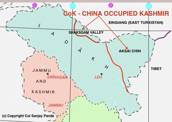
CoK is that part of UT of Ladakh, India under physical occupation of China. It is held in two separated geographical land masses, Shaksgam Valley and Aksai Chin. See Map-1.

MAP-1
Geography
This is probably one of the remotest places on earth. The Pamir Mountains are a mountain range between Central Asia, South Asia, and East Asia, at the junction of the Himalayas with the Tian Shan, Karakoram, Kunlun, and Hindu Kush. They are among the world’s highest mountains. See Map-1 below. Kunlun and Karakoram ranges meet at Pamir Knot in North-West. India extends so far North would come as a surprise to many.
Aksai Chin. See Map-1 and identify the bulge of Aksai Chin. Of our interest are Karakoram and Kunlun Mountains. Area in between these two mountain ranges contain Aksai Chin. Karakoram cuts Aksai Chin completely from west whereas Kunlun mountains contain the complete plus additional area east of Aksai Chin in east. There is a small but distinct mountain range between these two called Lak Tsung Mountains. All three ranges run parallel. The area between Lak Tsung mountains and Karakoram contains Lingzi Thang Plains whereas area between Lak Tsung Mountains and Kunlun mountains contains proper Aksai Chin. We must understand these details corelating with Map-1 since this is where the entire game has been played and continuing.
Shaksgam Valley. Aksai Chin is just one part of Ladakh under China, Shaksgam Valley being other. Shaksgam Valley is formed by Shaksgam River and is located within Indian boundary west of Karakoram northern end. Shaksgam Valley stands ignored by the Indian establishment for which we will pay a heavy price in future.
Karakoram Pass. This pass is located outside Indian International boundary and approx. 100 km north of Daulat Beg Oldi. See Map-1.
Depsang Plains. At 17000 feet, Depsang plains are between Karakoram mountains and Lak Tsung Ranges towards north.
China Occupied Kashmir
Reality is that both, Shaksgam Valley and Aksai Chin, both Indian territory as per the map published by Govt of India, are in physical occupation and control of China. This should be, combined, referred as CoK or ‘China Occupied Kashmir’. If Pakistan Occupied Kashmir was PoK, what prevented us from using term CoK or ‘China Occupied Kashmir’ from the very same day? It is extremely important to understand the geography of that area to discern the Chinese intentions. I wish it was as simple as it looks.

MAP-2
Indian have hardly heard of Shaksgam Valley. Indian Military or Government assigns no importance to it. We overlook the fact that a very narrow piece of land separates Shaksgam Valley and China occupied Aksai Chin. China has been an expansionist state, a land grabber and an aggressor for more than 500 years. China is not comfortable with the small Indian border wedged between Shaksgam Valley and Aksai Chin. Aksai Chin and Shaksgam Valley have practically no habitation. The nearest inhabited regions are East Turkistan and Tibet. In the captured lands, ethnicity of population does not bother him. He subjugates or eliminates them. Xingiang was East Turkistan with Muslim population and Tibet is Buddhist. He has forcefully subjugated both.
Shaksgam Valley. We will cover it in brief. Shaksgam Valley was considered by China as a ‘boundary dispute’ with Pakistan. Pakistan, in 1959, sent a note to settle border dispute to China which was ignored. Soon Pakistan voted for China for the UN Security Council seat. China reciprocated by withdrawing its claims and invited Pakistan to settle border dispute. In 1963, Pakistan signed the treaty and ceded the entire Shaksgam Valley to China, a land mass of approx. 5300 sq km. With India nowhere on the scene, the Shaksgam valley has gone forever. Here are some questions:
- How many times has ceding of Shaksgam Valley been discussed in Parliament of India since 1963?
- Has any Prime Minister spoken publicly on Shaksgam Valley?
- Have there been any diplomatic initiatives to regain Shaksgam Valley?
- Why does India not declare the area as “China Occupied Kashmir”?
- Why is there stony silence in India on Shaksgam Valley?
- Why is no mention of Shaksgam Valley in any communication from Government, Media, Govt funded strategy institutes, TV panelists, retired veterans, retired Army Commanders of Northern Command etc.?
- Where does Shaksgam Valley lie in military plans?
- Is army capable of launching military operations to recover the Shaksgam Valley?
- Does the Government have plans to defend the small border between Aksai Chin and Shaksgam Valley, both under the physical occupation of China?
- Has there been any military movement in Shaksgam Valley, either Indian Army or PLA?
Aksai Chin.
‘AKSAI CHIN’ name has various origins. It is believed to be a Turkic word meaning ‘white stone desert’, another language gives it a meaning of ‘pass’ whereas in Yarkandi it means ‘east’ and in any case, no one, except Chinese relate it to the ‘China’ as being closest meaning. Aksai Chin is desolate with average height of 12,000 ft. It is inhospitable and gained importance being on trade route between Tibet and East Turkistan. In 1842, the Dogras had defeated Tibetan Army which was the Qing Dynasty Army. Aksai Chin was captured by Dogras and later on a treaty was signed between the two. This is the earliest history of Aksai Chin.
Dogras crossed the international boundary as being depicted by India today and established a garrison in Shahidullah on the base of Kunlun mountains beyond the eastern tip of Aksai Chin. Dogras has their posts at Khurnak, Gartok and extending to Mayum Pass on the North-Western tip of Nepal. Aksai Chin again figured in 1865, 1893, 1897, 1899 and 1912. From Dogras and Sikhs to Britain to Qing Dynasty, all were involved with this area.
Here are some questions for India:
Here are some questions:
- Did India ever have complete physical control of Aksai Chin as depicted in the map of Ladakh?
- How many times has Aksin Chin being part of sovereign India been discussed in Parliament of India since 1947?
- Has any Prime Minister spoken publicly on Aksai Chin?
- Have there been any diplomatic initiatives to regain Aksai Chin?
- Why does India not declare the area as “China Occupied Kashmir”?
- Why is there stony silence in India on Aksai Chin?
- Why is no mention of Aksai Chin in any communication from Government, Media, Govt funded strategy institutes, TV panelists, retired veterans, retired Army Commanders of Northern Command etc.?
- Where does Aksai Chin lie in military plans?
- Is army capable of launching military operations to recover the Aksai Chin?
- Does the Government have plans to defend the small border between Aksai Chin and Shaksgam Valley, both under the physical occupation of China?
- Has there been any military movement in Aksai Chin, either Indian Army or PLA, if yes where?
My next article “Aksai Chin – 3 : Britain and Conflicting Boundaries” covers the period from 1865 to 1912, and 1912 to 1947.
We are coming very close to understanding the mess.
Col Sanjay Pande
© Copyright
10 thoughts on “Article No. 7 : AKSAI CHIN – 2 : CHINA OCCUPIED KASHMIR : HISTORY AND GEOGRAPHY”
Leave a Reply
Recent Posts
Mr Macha was born about two weeks ago. He is the first case where he grew each day by one year! He is 19 years old today. Mr Macha is all fun, frolic, health conscious and really cares about...
2012-Present : Advisor-Consultant for MNCs (Multi National Companies) Details covered separately on the website. 2012 - Present Kshemin Technologies Pvt. Ltd. Founded an independent...
Interesting and thought provoking. However, the people whose thoughts must be provoked, remain totally aloof. We are alive to the issue but have no power to influence. Anyway, suggest cover Daulat Beg Oldi, too.
Coming slowly down from East Turkistan-Tibet to Aksai Chin to ranges, plains, and famous names. Thank you for suggesting. Be frank, how is it coming up?
Thread on Depsang Plains and Aksai chin.
DEPSANG :
1. Beefed up Tianwendian. https://t.co/bxbHVG4eo6
Brilliant images. I am of firm belief that China wants land link up with Shaksgam Valley. Your view?
sinister plan
https://www.scmp.com/week-asia/economics/article/3119850/will-new-road-between-china-and-pakistan-lead-military-boost
Sir , not able to upload image here! You can view my reply here !
1. https://twitter.com/NatureDesai/status/1363780471386218497
2. https://twitter.com/NatureDesai/status/1364459678055288832
Your narration , Historical Rearserch and Geographical pint pint of the Subject matter has to be applauded. Unfortunately India has bigger domestic enemies which occupy the states resources henceforth we have never been able to advanced our Military Might. Indian Army should be a self sustainable and indelendently functioning identity of the nation so that we can deal with the National threats effectively . Failure to do so will result in the repatative Era of 1100 to 1947. So think twice BHARAT what you want and what you need .
Jai Hind
Har Har Mahadev
Dear Vinod,
My deep apologies for such a delayed reply. It was more to do with excessive writing that I am doing. That in any case does not reduce my guilt.
Thank you for detailed comments.
Warm regards
Sanjay
Apt Col never heard of the Shaksham valley from locals too
Strange been a teacher at Lamdon school Leh
Not even locals are aware of it am sure
Articles written by u makes me wonder why are the officers too ignorant about it
Madam,
Officers are trained to run with blinkers on. Have you seen Retired Army Commanders latest YouTube Video> Gen Panag and Gen Hooda talk of Pangong Tso fingers, 100 meters, 500 meters or one km. Have you EVER heard them talking FIVE KILOMETERS BEHIND LAC? This is our miserable state.
I write in public domain, articles are on website, the world scrutinises and the world is more interested in finding faults rather than praise. Not even one counter to my six articles to date.
You are a wonderful support.
Warm regards
Sanjay