Aksai Chin – 3 : British India and Conflicting Boundaries 01 Mar 2021
Pamir knot is the hub center. Himalayas and Karakoram in South-East direction and Kunlun mountains in eastern direction contain Shaksgam Valley and Aksai Chin.
Historically, China Border issue is not about China and India but about British India and Russia. Why is this fact not brought up in debates? Neither China nor India inherited any boundaries so why at loggerheads? Why exactly is India-China border issue more about ego than practicality? While one country gained independence, the other was closer to communist revolution. When the revolution succeeded, frantic activity of land grab commenced. India lost out right from start. Hence it is imperative that we first understand why either country did not inherit any boundary. With India under British control, it had no powers to interact with any foreign power. At places where the British did not have direct control, the powers that ruled interacted with foreign powers. Ladakh was one such region. “Galwan Bloodshed” of 2020 has its seed sown in 1842. Three boundaries and loads of ego. This is the story of three boundaries.
The First Boundary: 1842 Chushul Treaty

MAP-1
The First Boundary. Sikh Kingdom spanned across Punjab and nearly touched Delhi, in the North they had complete Jammu and Kashmir. In 1823 the Sikhs declared Gulab Singh as ‘Raja’ and gave him all areas North of Ravi River. Soon entire Jammu region, Kashmir and Ladakh were with Gulab Singh. The invasion of Tibet in 1842 resulted in Chushul Treaty with representatives of Qing Dynasty of China. The first boundary was born. Qing and Dogras agreed to adhere to arrangements from ‘ancient’ times and to respect it. The Tibet-Turkistan trade route passed through Aksai Chin and was considered part of Aksai Chin. Qing Dynasty did not come west of Kunlun Mountains. There were no points defining the boundary but the ancient understanding was that the trade route and Aksai Chin area was part of Ladakh region. The blue dots in Map-1 give the rough alignment of the understanding as thought of in 1842 except that easternmost point of Pangong Tso Lake and Karakoram Pass were defined but no points within Aksai Chin were mentioned. In absence the traditional trade route was understood to be the boundary.
Interesting part is that line joining Khurnak Fort, Gartok to Mayun La near Nepal was opened to British under the 1904 Lahsa Treaty. Prior to that from 1842 to 1890 this alignment had number of Dogra garrisons. Just to give an idea, the blue line in Map-2 is the rough alignment along which the Dogras maintained garrisons. The easternmost garrison was at Mayum Pass well beyond Mansarovar Lake.

MAP-2
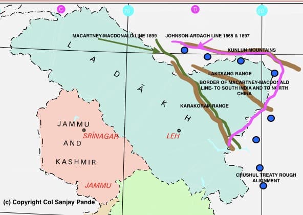
The Second Boundary : 1865 & 1897 Johnson-Ardagh Line

MAP-3
The Second Boundary: 1865 & 1897 Johnson-Ardagh Line MAP-3 refers. The Johnson-Ardagh Line is shown in pink. Russian expansionism towards south bothered British and the boundaries were drawn keeping defensive lines in mind. China was nowhere in the thoughts of Britain. The rough alignment is in pink colour in Map-3.
Johnson Line owes the name to Mr Johnson of Survey of India who defined the line in 1865 between British India and Tibet, then under Qing Dynasty. However the north of Tibet, East Turkistan was under revolt and China did not have control over the area. Johnson took Kunlun mountains as dividing line. This line started from Karakoram Pass and followed the lower western areas of Kunlun mountains. The maps were not presented to Chinese due to the revolt but were presented to Maharaja of Kashmir who included entire area as part of Ladakh. No development took place for three decades thereafter.
In 1897, the British worried about weak China and strong Russian expansionism, decided to redraw the boundary between India and Tibet. A British Military Officer, John Ardagh suggested a more defensible line along the ‘crest’ of Kunlun Mountain Range. This line more or less followed the 1865 Johnson Line. Ardagh line was a modification to Johnson line and has been referred to as ‘Johnson-Ardagh’ line since 1897.
The Third Boundary : 1899 Macartney-Macdonald Line

MAP-4
The Third Boundary Line : 1899 Macartney-Macdonald Line. The seeds of mess were sowed here. In 1893, Hung Ta-chen, Chinese representative stationed in St. Petersburg, Russia, submitted a map to George Macartney, the British Counsel General in St. Petersburg. The boundary coincided with the Johnson Line, which, if you refer to Map 3 above was on the western/southern base of Kunlun mountains. Hence, from 1865 to 1893 and thereafter from 1893 to 1897 (when Ardagh line was drawn and it went over the ‘crests’ of Kunlun mountains) the Chinese and British India were in sync and the small difference was whether the base or crests of Kunlun mountains.
Russia expansionism was a factor of worry for Britain. In 1899, the Governor General of India, Lord Elgin proposed another boundary, again suggested by George Macartney that put the boundary over Karakoram mountains and the complete expanse from Karakoran mountains to Kunlun Mountains was ‘explained’ in the note. We will refer to this area as ‘Laktsang’ mountains and is covered in detail later. This line was presented to Qing Government by Claude MacDonald hence referred to as “Macartney-Macdonald Line’. Qing Government did not respond.
The state in 1899 was that there were two lines, the Johnson-Ardagh line and the Macartney-MacDonald line. The Macartney-MacDonald Line is responsible for all Chinese intrusions and hence is covered below.
Laktsang Mountains. The Laktsang Mountains are parallel to Karakoram and divide Aksai Chin into two distinct parts. To the west and south of this range are Lingzi Tang plains that British placed with India and to the north and east of Laktsang mountains is Aksai Chin proper which was placed with China. If this was the understanding then the boundary should have been placed on Laktsang mountains. The British placed the boundary on Karakoram but suggested an understanding on areas east of it. The complete India China fight is hidden in this paragraph.
Implications of the three boundaries.
It is so easy for a reader to see the implications today:
- China is trying to completely capture Karakoram Range since it has taken the liberty to follow Macartney-MacDonald Line.
- India claims complete area up to Kunlun Mountains since it has taken liberty to follow Johnson-Ardagh line.
- Historically China never confirmed accepting any line.
- Historically Maharaja of Jammu accepted line up to Kunlun Mountains.
- British quietly left the country leaving every disputed issue more complicated that it was when they got involved initially.
This article effectively brings to close all issues from 1840 to 1912. Qing Dynasty was removed by Provisional Government of Republic of China (PGRC) and from 1912 to 1949 is a distinctive period for India-Britain and China. I shall cover than in the next article “Aksai Chin – 4 : The Britain-India-China Triangle Breaks – 1912-1949”.
Col Sanjay Pande
© Copyright
2 thoughts on “Article No. 8 : Aksai Chin – 3 : British India and Conflicting Boundaries”
Leave a Reply
Recent Posts
Mr Macha was born about two weeks ago. He is the first case where he grew each day by one year! He is 19 years old today. Mr Macha is all fun, frolic, health conscious and really cares about...
2012-Present : Advisor-Consultant for MNCs (Multi National Companies) Details covered separately on the website. 2012 - Present Kshemin Technologies Pvt. Ltd. Founded an independent...
All hail British. They justified their rule on India by fooling Indians about their history. Arunachal pradesh or aksai chin was never part of India during Mauryan or Gupta empire, British firstly expired and added in their empire. Mughal was the first Indian occupational empire which conquered entire Ladakh ( As shown in Ladakh UT map).Eastern Himalayas were natural boundary between two Asian giants as there was no way to invade with greater strength from both sides! All that Britishers had done to its colonies is now happening with them.( Ireland / Scotland wants independence from Britain )
Sanjay, Excellent articles giving out the historical reasons for the non acceptance of boundaries between India and China. Wish
it gets wider audience. The crux is the ‘Macartney-Macdonald Line’ and ‘Johnson-Ardagh Line’ drawn on quarter inch maps with thick lines as also work in progress of what to occupy